
Have you ever wondered how did sailors, merchants, and travelers found their way in the ancient days when they didn’t have phones with GPS and Google Maps in their pockets?. Well, when you were in the middle of the sea and you wanted to go home without any of those tools, you had to know how to find the direction you were traveling towards. Fortunately, there are many natural marks in the sky that can tell you this, all you need to do is learn to read them. Using the sky to find your way around is called celestial navigation.
The most basic celestial navigation skill you can learn and a fun party trick you can use to show off next time you go camping is finding the four cardinal points so you know which direction you are traveling to. It can be also a very important survival skill for people that enjoy going into the wilderness, hiking or traveling to remote places as you never know when for some reason or another you will be without any instruments. Maybe your phone battery died and you don’t have a compass at hand and the terrain doesn’t have any useful landmarks.
First, let’s start with some definitions on what cardinal points are and what is True North. You can skip this section and go straight to the practical tips if you already know this.
What are cardinal points?
The four cardinal points are North, East, South, and West going clockwise. They allow you to know your direction in relation to Earth. The North is located in the top spot of Earth where the magnetic pole is. You can remember the names of the cardinal direction by using the mnemonic NEWS (North, East, West, South).
The difference between cardinal points and simply saying “left”, “right”, “up”, etc. is that those directions are in relation and could change depending on your position and direction while cardinal points are always in the same direction so they are a better standard for communicating directions.
The four intermediate directions located between the cardinal points are called InterCardinal directions and are Northeast, Southeast, Southwest, and Northwest.
Defining True North
You might have heard the term “True North” and wondered what it means. Are there multiple Norths or why would need a true one?.
It turns out when people say North, they could mean different things. First, you have the Geographical North. This is also called True North and it is the point in the middle of the Arctic Ocean where the North Pole is. If you trace a line from the North Pole to the South Pole, you get the imaginary axis around which Earth rotates.
Next, you have the Magnetic North. This is the point where the magnetic lines of the magnetic field that surrounds Earth enter the planet. Because this magnetic field is constantly shifting, this point moves between 10 and 40 kilometers every year so it is not exactly located in the North Pole, it is currently located about 500 kilometers away. This Magnetic North is the direction compasses point to.
Fun fact: Because the Magnetic Field moves around, at some point it’s polarity is inverted and the Magnetic Pole moves South. That means that someday, compasses will point South instead of North. This process is very slow and happens over a period of hundreds of thousands of years so we don’t need to worry about re-writing our science books for a while.
Now that we know what the True North is, how do we find directions using celestial navigation? but before that, here’s a general tip.
If you find a cardinal point, you can deduce all the others
Because the cardinal points are structured like a clock, you can figure out where all the positions simply by finding one. For example, if you find East, all you need to do is position yourself facing that direction. If you lift your left arm, it will be pointing North, your right arm would be pointing South and West will be behind you.
Finding East and West
Method 1: Watch the sunrise or sunset
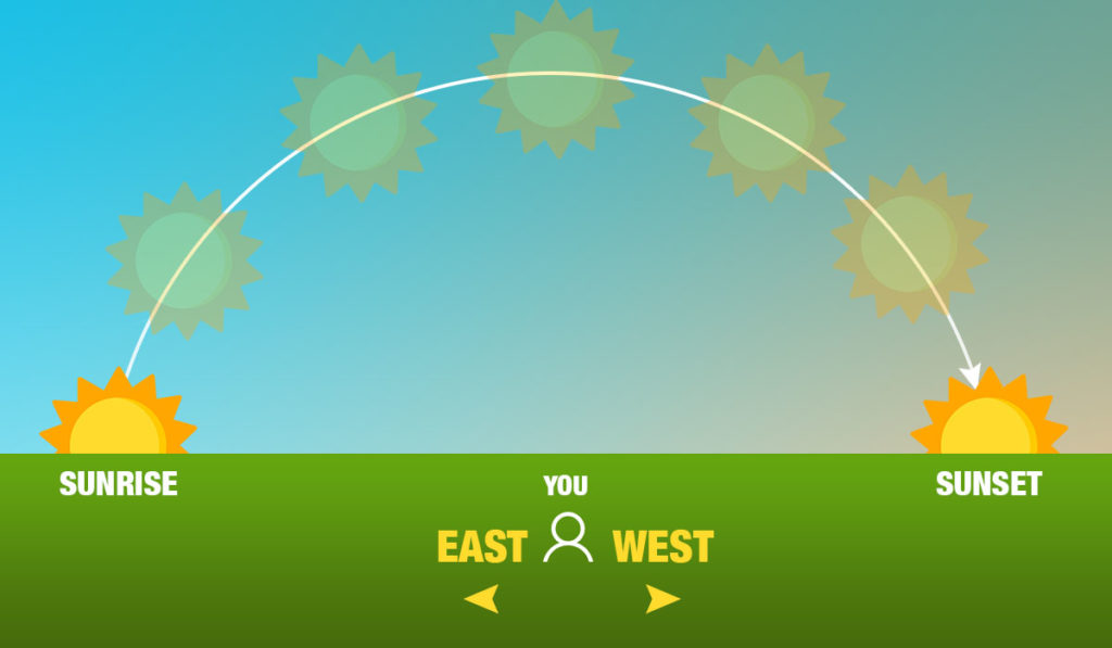
Earth rotates to the East. Because of the direction of this rotation, all the stellar objects will rise in the East and move across the sky during the day towards the West where they disappear.
Because Earth’s axis is slightly inclined and tilts as the year progresses (causing the seasons) this method isn’t 100% precise, but generally, it is easy enough and good enough to give you an idea of the direction.
All you need to do is watch where the direction from where the sun rose or where it’s setting, the former will be East and the latter West. You can use the same method using the moon during nighttime.
Method 2: The stick method
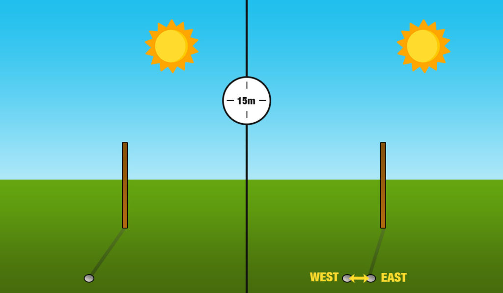
What happens if it’s the middle of the day and you aren’t sure where the sun rose? This method solves this. The steps are simple:
- Find a thin stick or some other kind of similar object that you can stick on the ground and creates a clear shadow.
- Set the stick vertically in the ground
- Mark the point where the shadow ends with a small rock or a hole in the ground
- Wait 10-15 minutes. The shadow will move.
- Mark the new point where the shadow ends.
- Draw or imagine a line joining both marks
This line you drew from the first point to the second goes from East to West. Now you have two cardinal points to know your position.
Finding True North
Method 1: Use the stick method
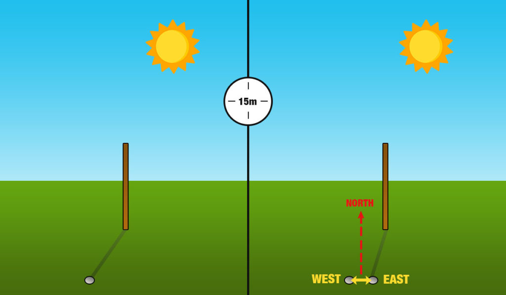
The easiest way to find North during the day is to use the stick method explained above to find East and West. Once you have done that, add the following step:
Line up both of your feet on the East-West line you, making sure your right foot is in the East side. Your eyes will be looking about 90 degrees from this line. This is North.
Method 2: Find Polaris (the North Star)
Now let’s proceed to some methods that you can use during nighttime.
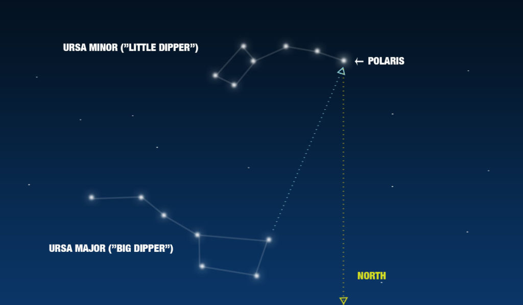
If you are in the Northern hemisphere, it is very simple to find North at night simply by locating one star: Polaris.
Polaris, also known as Ursae Minoris or more commonly as the North Star is the brightest star in the Ursa Minoris (“the little dipper”) constellation. This star lines up almost perfectly with Earth’s rotation axis which means it is always pointing North. If you were to take continuous photos of the sky at night with Polaris at the center, it would seem as if the rest of the stars rotate around it.
To find Polaris, first try to locate the Ursa Major (“big dipper”) constellation as it’s shape is easy to recognize. If you draw an imaginary line using the two last stars in the “dipper” part it points almost exactly to Polaris.
Once you have found Polaris, imagine a straight line down towards Earth. That direction is North.
Please note Polaris is only visible in the Northern hemisphere so this method doesn’t work in all parts of the world.
Method 3: The double stick method

As mentioned previously, the North Star method only works in the Northern hemisphere. Here’s one that works everywhere.
This is a variation of the stick method used previously, but since there are no shadows during nighttime, we have to get a bit more creative. Follow these steps:
- Find two sticks that you can stick in the ground.
- Look at the star and find the brightest star you can see. Any star will work, just make sure it is recognizable and you can keep track of it.
- Line both sticks a couple feet apart from in each other in such a way that they both line up in a straight line with the star you chose.
- Wait 10-15 minutes
- Check the straight line your sticks mark
If the star moves to the left, then that direction is West, if it moves to the right, then West is to your right.
Method 4: The watch method
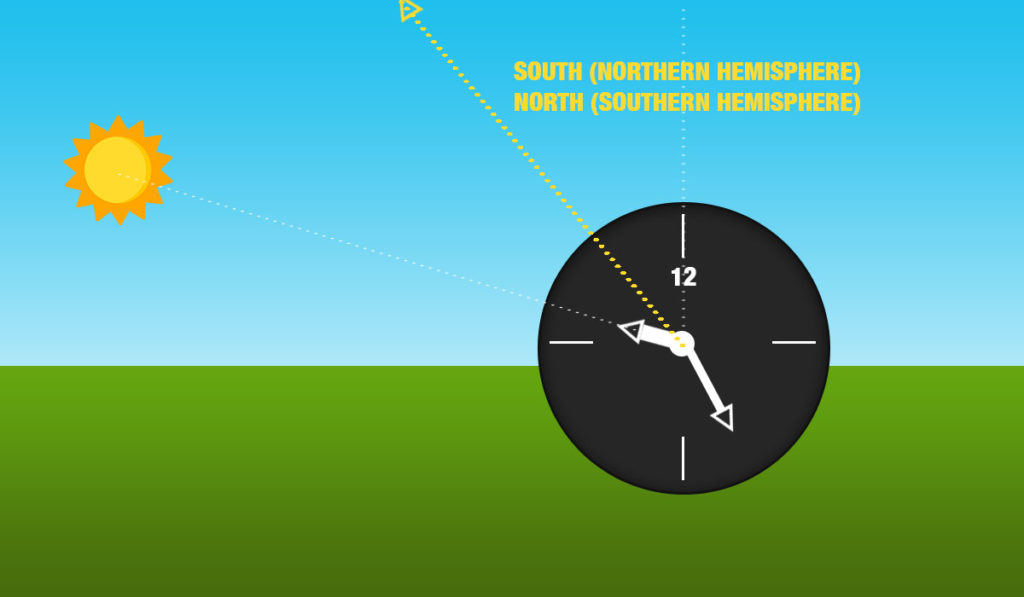
A different method to find North is to use an analog watch. We left it last because it requires equipment, it only works during daytime and the fact that it works differently depending on the hemisphere you are in makes it more complex, but it’s simple to execute and it’s good to know it anyway. Just follow these steps:
- If the clock is set to Daylight Savings Time, adjust it one hour back.
- Point the hour hand to the Sun
- Look for the 12-hour mark on the watch. The imaginary line from the 12-hour mark to the hour form an angle, keep it in mind.
- Imagine a line that splits that angle exactly in half
5n. If you are in the Northern Hemisphere, that line points South. North is exactly in the opposite direction.
5s. If you are in the Southern Hemisphere, that line points North.
Conclusion
As you can see, there are many methods to figure out your direction so it’s no wonder sailors were able to find their way home reliably without much technology.
There are other methods to find the different cardinal directions, but some of them are not reliable and do not involve watching the sky. For example, if you are in a forest and it’s too cloudy, some people suggest moss tends to grow on the north side of trees, however, this isn’t 100% reliable so we prefer to leave it out. Let us know in the comments if you know any other methods we might have missed.
Enjoyed this article?
Get daily 10-minute PDFs about astronomy to read before bed!
Sign up for our upcoming micro-learning service where you will learn something new about space and beyond every day while winding down.


")
