
Earth is watched constantly by a mix of long-running and short-lived satellites that map weather, track greenhouse gases, monitor sea level and observe land use. That steady stream of measurements underpins forecasts, climate research and disaster response across the globe.
There are 60 NASA Missions to Earth, ranging from A-Train Constellation (conceptual grouping) to Terra (EOS AM-1). Each entry is organized with Launch date (UTC),Status,Orbit (type; altitude (km)) so you can quickly compare timing, operational state and orbital characteristics — you’ll find below.
How is the A-Train different from single-satellite missions like Terra?
The A-Train is a coordinated constellation where multiple satellites fly in close formation to provide complementary, near-simultaneous observations; single platforms like Terra carry broader instrument suites on one spacecraft, offering long-term continuity rather than synchronized multi-satellite sampling.
What’s the easiest way to find missions by orbit or current status?
Use the provided columns: sort or filter by Launch date (UTC) to see chronology, by Status to isolate active versus retired missions, and by Orbit (type; altitude (km)) to identify LEO, polar, sun-synchronous or higher-altitude platforms; exporting the list to a spreadsheet makes these filters quickest.
Nasa Missions to Earth
| Name | Launch date (UTC) | Status | Orbit (type; altitude (km)) |
|---|---|---|---|
| Landsat 1 | 1972-07-23 | Completed | LEO sun-synchronous; 917 km |
| Landsat 2 | 1975-01-22 | Completed | LEO sun-synchronous; 917 km |
| Landsat 3 | 1978-03-05 | Completed | LEO sun-synchronous; 917 km |
| Landsat 4 | 1982-11-16 | Completed | LEO sun-synchronous; 705 km |
| Landsat 5 | 1984-03-01 | Completed | LEO sun-synchronous; 705 km |
| Landsat 6 | 1993-10-05 | Cancelled | LEO sun-synchronous; failed to reach orbit |
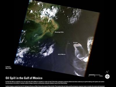
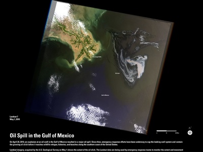
| Landsat 7 | 1999-04-15 | Active | LEO sun-synchronous; 705 km |
| Landsat 8 | 2013-02-11 | Active | LEO sun-synchronous; 705 km |
| Landsat 9 | 2021-09-27 | Active | LEO sun-synchronous; 705 km |
| Terra (EOS AM-1) | 1999-12-18 | Active | LEO sun-synchronous; 705 km |
| Aqua | 2002-05-04 | Active | LEO sun-synchronous; 705 km |
| Aura | 2004-07-15 | Active | LEO sun-synchronous; 705 km |
| Suomi NPP | 2011-10-28 | Active | LEO polar; 825 km |
| OCO (Orbiting Carbon Observatory) | 2009-02-24 | Cancelled | Launch failure; failed to reach orbit |
| OCO-2 | 2014-07-02 | Active | LEO sun-synchronous; 705 km |
| OCO-3 | 2019-05-04 | Active | ISS-attached; ~408 km |
| ICESat | 2003-02-12 | Completed | LEO; 600 km |
| ICESat-2 | 2018-09-15 | Active | LEO sun-synchronous; 500 km |
| GRACE | 2002-03-17 | Completed | LEO; 500 km |
| GRACE-FO | 2018-05-22 | Active | LEO; 490 km |
| TOPEX/Poseidon | 1992-08-10 | Completed | Non-sun-synchronous LEO; 1,330 km |
| Jason-1 | 2001-12-07 | Completed | LEO; 1,330 km |
| Jason-2 | 2008-06-20 | Completed | LEO; 1,330 km |
| Jason-3 | 2016-01-17 | Active | LEO; 1,330 km |
| Sentinel-6 Michael Freilich (Jason-CS) | 2020-11-21 | Active | LEO; 1,330 km |
| TRMM (Tropical Rainfall Measuring Mission) | 1997-11-27 | Completed | Low-inclination LEO; 350 km |
| GPM Core Observatory | 2014-02-27 | Active | LEO; 407 km |
| SMAP | 2015-01-31 | Active | LEO sun-synchronous; 685 km |
| Aquarius | 2011-06-10 | Completed | LEO sun-synchronous; 657 km |
| QuikSCAT | 1999-06-19 | Completed | LEO sun-synchronous; 800 km |
| CALIPSO | 2006-04-28 | Completed | LEO sun-synchronous; 705 km |
| CloudSat | 2006-04-28 | Active | LEO sun-synchronous; 705 km |
| SeaWiFS (Sea-viewing Wide Field-of-view Sensor) | 1997-08-01 | Completed | LEO sun-synchronous; 705 km |
| SAGE III on ISS | 2017-02-19 | Active | ISS-attached; ~408 km |
| SORCE | 2003-01-25 | Completed | LEO sun-synchronous; 645 km |
| TSIS-1 (Total and Spectral Solar Irradiance Sensor) | 2017-12-?? | Active | ISS-attached; ~408 km |
| GEDI | 2018-12-05 | Completed | ISS-attached; ~408 km |
| GRACE-FO Laser Ranging Interferometer (technology on GRACE-FO) | 2018-05-22 | Active | LEO; 490 km |
| DSCOVR | 2015-02-11 | Active | Sun–Earth L1; ~1,500,000 km |
| ICESat-2 ATLAS (instrument mission context) | 2018-09-15 | Active | LEO sun-synchronous; 500 km |
| AIRS on Aqua (mission instrument context) | 2002-05-04 | Active | LEO sun-synchronous; 705 km |
| ACE (Aerosol/Cloud/Ecosystems pathfinder context) | 1999-07-25 | Completed | LEO; 600 km |
| Operation IceBridge | 2009-03-07 | Completed | Airborne; variable altitude |
| ATom (Atmospheric Tomography Mission) | 2016-07-05 | Completed | Airborne global; variable altitude |
| DISCOVER-AQ | 2011-07-01 | Completed | Airborne; variable altitude |
| Airborne Snow Observatory (ASO) | 2013-01-01 | Active | Airborne; variable altitude |
| AirMOSS | 2012-05-01 | Completed | Airborne; variable altitude |
| SMILES (mission context — JAXA led, not included) | N/A | N/A | N/A |
| PACE (Plankton, Aerosol, Cloud, ocean Ecosystem) | 2024 | Planned | LEO sun-synchronous; 676 km |
| NISAR (NASA–ISRO Synthetic Aperture Radar) | 2024 | Planned | LEO sun-synchronous; 747 km |
| TEMPO (Tropospheric Emissions: Monitoring of Pollution) | 2023-04-?? | Active | GEO; 35,786 km |
| GeoCarb | Planned | Planned | GEO; 35,786 km |
| Glory | 2011-03-04 | Cancelled | Launch failure; failed to reach orbit |
| SEAC4RS (Studies of Emissions, Atmospheric Composition, Clouds and Climate Coupling) | 2013-08-01 | Completed | Airborne; variable altitude |
| MAIA (Multi-Angle Imager for Aerosols) | 2022-01-?? | Active | LEO; 400 km |
| OCO-1 (failed) [alternate name OCO] | 2009-02-24 | Cancelled | Launch failure; failed to reach orbit |
| ICESat (mission alternate name GLAS flight) | 2003-02-12 | Completed | LEO; 600 km |
| MODIS (instrument on Terra/Aqua context) | 1999-12-18 | Active | LEO sun-synchronous; 705 km |
| A-Train Constellation (conceptual grouping) | 2000s | Varied | LEO sun-synchronous; ~705 km |
| SMILES note removed | N/A | N/A | N/A |
Images and Descriptions
Landsat 1
The original Landsat began systematic, global land imaging to monitor Earth’s land cover, agriculture and water. It carried multispectral scanners providing long-term records that underpin land use, climate studies and resource management globally.
Landsat 2
Follow-up to Landsat 1, Landsat 2 continued multispectral land imaging to track vegetation, urban growth, and water resources. It extended the valuable multi-decadal record of Earth’s surface change used by scientists and resource managers.
Landsat 3
Landsat 3 provided continued multispectral observations of Earth’s land surfaces, supporting mapping, agriculture and environmental monitoring and helping build the longest continuous global land-imaging data record.
Landsat 4
A major Landsat upgrade, Landsat 4 carried improved sensors and began the transition to lower, more stable orbits. It advanced land-cover mapping, natural-resource management and long-term climate-related surface change studies.
Landsat 5
Landsat 5, one of the longest-lived Earth-observing satellites, provided decades of consistent multispectral imaging used for agriculture, forestry, glacier and urban-change studies, extending critical historic records.
Landsat 6
Landsat 6 failed to reach orbit on launch; it was intended to continue the Landsat record with modern sensors but never became operational.
Landsat 7
Landsat 7 carried the Enhanced Thematic Mapper to produce high-resolution land imagery. Despite a scan-line issue in 2003, its data remain vital for land-change, water and disaster studies.
Landsat 8
Landsat 8 provides improved multispectral and thermal imaging with reliable data continuity for mapping, climate research, agriculture monitoring and disaster response, forming part of the long Landsat record.
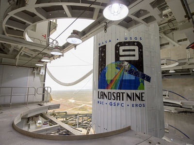
Landsat 9
Landsat 9 continues the Landsat program with updated instruments, ensuring continued high-quality global land imaging for conservation, climate monitoring, water resources and land-use decision-making.
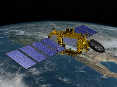
Terra (EOS AM-1)
Terra is NASA’s flagship Earth-observing platform carrying MODIS, MISR, CERES and other instruments to study land, atmosphere and oceans. It tracks climate trends, aerosols, clouds and global energy balance.
Aqua
Aqua focuses on the water cycle with sensors like MODIS and AIRS measuring clouds, precipitation, ocean temperatures and atmospheric humidity—critical for weather, climate and hydrology research.

Aura
Aura studies Earth’s atmosphere, ozone, air quality and trace gases with instruments such as MLS and TES. Its long-term atmospheric chemistry record informs climate change and pollution science.
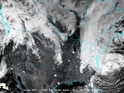
Suomi NPP
Suomi NPP is a NOAA–NASA partnership carrying VIIRS, CrIS and ATMS instruments. It bridges weather and climate observations, providing improved global imaging, atmospheric sounding and environmental monitoring.

OCO (Orbiting Carbon Observatory)
OCO was designed to precisely measure atmospheric carbon dioxide but failed at launch. Its loss drove the development of successor missions to observe global carbon sources and sinks.
OCO-2
OCO-2 measures atmospheric CO2 with high precision and spatial resolution to track carbon sources, sinks and transport—key to understanding the global carbon cycle and climate feedbacks.
OCO-3
Mounted on the ISS, OCO-3 maps carbon dioxide at city-to-regional scales and studies how human activities and ecosystems influence atmospheric CO2, complementing OCO-2’s global record.
ICESat
ICESat used laser altimetry to measure ice-sheet elevation and sea-ice thickness, providing critical data on polar ice loss and elevation change that improved our understanding of sea-level rise.
ICESat-2
ICESat-2’s photon-counting lidar maps 3-D topography of ice sheets, sea ice and forests at high precision. Its measurements are essential for quantifying ice mass loss and monitoring coastal change.

GRACE
GRACE measured Earth’s gravity field variations via twin satellites to infer changes in terrestrial water storage and ice mass, revealing groundwater depletion, ice loss and mass redistribution.
GRACE-FO
GRACE Follow-On continues GRACE’s twin-satellite gravity measurements to monitor Earth’s changing water and ice mass, informing hydrology, sea-level rise and climate studies.
TOPEX/Poseidon
TOPEX/Poseidon was a pioneering ocean altimeter mission that precisely measured sea-surface height, advancing understanding of ocean circulation, tides and climate variability like El Niño.
Jason-1
Jason-1 continued satellite altimetry records of sea-surface height, providing critical data for oceanography, sea-level rise monitoring and climate research in partnership with international agencies.
Jason-2
Jason-2 sustained the global sea-level record with precise altimetry, improving models of ocean circulation, tides and climate-driven sea-level changes.
Jason-3
Jason-3 provides continuity in monitoring global sea-surface height, helping scientists track sea-level rise, ocean currents and inform climate and weather models.
Sentinel-6 Michael Freilich (Jason-CS)
A NASA–NOAA–European partnership, Sentinel-6 continues the altimetry record with high-precision sea-level measurements essential for climate monitoring, coastal planning and oceanography.
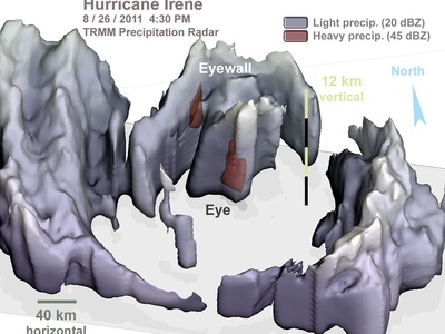
TRMM (Tropical Rainfall Measuring Mission)
TRMM studied tropical rainfall and storms with radar and microwave instruments, greatly improving understanding of precipitation processes and hurricane dynamics in the tropics.
GPM Core Observatory
GPM provides advanced precipitation measurements using microwave sensors to map global rain and snow, improve weather forecasting and understand hydrologic cycles across ecosystems.
SMAP
SMAP measures global soil moisture and freeze–thaw state via radar and radiometer, aiding agriculture, flood forecasting and carbon-cycle research by quantifying surface water storage.
Aquarius
Aquarius measured global sea-surface salinity to study ocean circulation and climate. Although its mission ended, Aquarius provided the first broad-scale salinity maps from space.
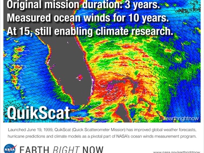
QuikSCAT
QuikSCAT used a scatterometer to map global ocean surface winds, improving weather models and storm monitoring before its antenna failure ended operations.
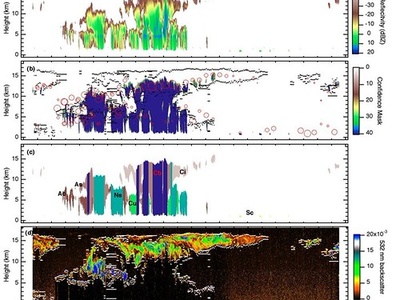
CALIPSO
CALIPSO combined lidar and passive sensors to profile clouds and aerosols vertically, improving understanding of particulate transport, air quality and climate forcing by aerosols.

CloudSat
CloudSat’s radar profiles cloud vertical structure worldwide, revealing hidden cloud water content and improving precipitation and climate models; it continues to provide valuable cloud-climate insights.
SeaWiFS (Sea-viewing Wide Field-of-view Sensor)
SeaWiFS was dedicated to ocean-color imaging to map global phytoplankton and primary productivity, vital for understanding carbon cycling and marine ecosystems.
SAGE III on ISS
SAGE III measures stratospheric aerosols, ozone and trace gases from the ISS to monitor ozone recovery, volcanic aerosols and long-term atmospheric composition changes affecting climate and air quality.
SORCE
SORCE measured total and spectral solar irradiance, clarifying how solar variability influences Earth’s climate system and improving energy-balance inputs for climate models.
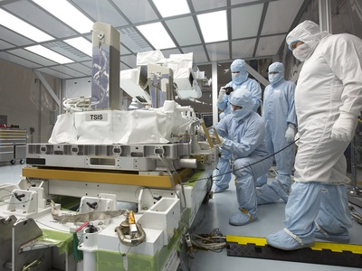
TSIS-1 (Total and Spectral Solar Irradiance Sensor)
TSIS measures precise solar irradiance across wavelengths to monitor solar input to Earth’s climate system, supporting climate studies and satellite calibration efforts.
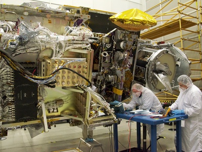
GEDI
GEDI used lidar on the ISS to map global forest structure and biomass, improving carbon stock estimates and informing climate mitigation through improved forest carbon accounting.
GRACE-FO Laser Ranging Interferometer (technology on GRACE-FO)
The Laser Ranging Interferometer aboard GRACE-FO demonstrates laser metrology for precise gravity-change measurements, enhancing Earth’s mass-change monitoring and future gravity-mapping capabilities.
DSCOVR
DSCOVR sits at L1 with EPIC imaging Earth and NISTAR measuring reflected sunlight, monitoring global radiation balance and providing continuous full-disk Earth images for climate and atmospheric studies.
ICESat-2 ATLAS (instrument mission context)
ICESat-2’s ATLAS lidar provides high-precision elevation profiles across ice sheets, glaciers and forests—crucial for quantifying mass loss, sea-level rise contributions and vegetation structure.
AIRS on Aqua (mission instrument context)
AIRS is a key Aqua instrument providing high-resolution atmospheric temperature and humidity profiles, improving weather prediction, climate monitoring and studies of atmospheric composition.
ACE (Aerosol/Cloud/Ecosystems pathfinder context)
ACEs and related field campaigns studied aerosol–cloud interactions; NASA-led airborne and satellite efforts advanced understanding of aerosols’ climate effects and helped improve climate model representation.
Operation IceBridge
A multi-year NASA airborne campaign that measured polar ice thickness and topography with radar and lidar, bridging data gaps between ICESat missions and documenting rapid ice-sheet changes.
ATom (Atmospheric Tomography Mission)
ATom deployed research aircraft across oceans to profile atmospheric chemistry and aerosols, improving understanding of how human and natural emissions affect air quality and climate.
DISCOVER-AQ
DISCOVER-AQ was a NASA airborne campaign to link satellite observations with ground-level air quality, improving satellite-based air pollution retrievals for public health and regulatory use.
Airborne Snow Observatory (ASO)
ASO uses airborne lidar and imaging spectroscopy to map snow depth and water content in mountain catchments, improving water-resource forecasting and informing water management decisions.
AirMOSS
AirMOSS used airborne P-band radar to measure root-zone soil moisture under forest canopies, helping quantify carbon–water interactions and informing climate and ecosystem models.
SMILES (mission context — JAXA led, not included)
N/A
PACE (Plankton, Aerosol, Cloud, ocean Ecosystem)
PACE will carry hyperspectral and polarimetric sensors to study ocean color, aerosols and clouds, advancing knowledge of marine ecosystems, air quality and climate with highly detailed spectral observations.
NISAR (NASA–ISRO Synthetic Aperture Radar)
NISAR, a major NASA–ISRO partnership, will map Earth’s land and ice surface deformation with radar interferometry to study earthquakes, ice dynamics, sea-level change and ecosystem disturbances globally.
TEMPO (Tropospheric Emissions: Monitoring of Pollution)
TEMPO observes North American air pollution from geostationary orbit hourly, measuring ozone precursors and aerosols to support air-quality forecasting, health studies and pollution source attribution.
GeoCarb
Planned to monitor carbon dioxide, methane and carbon monoxide over the Americas from geostationary orbit, GeoCarb aims to resolve regional fluxes and help link human activities to carbon variability.
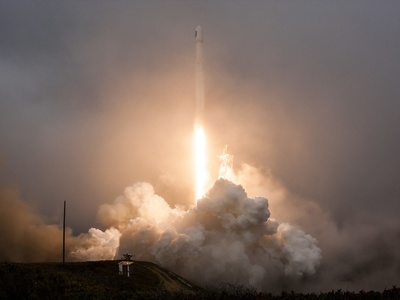
Glory
Glory was designed to measure aerosols and solar irradiance to better quantify aerosol climate forcing. It was lost in a launch failure, delaying critical aerosol-climate observations.
SEAC4RS (Studies of Emissions, Atmospheric Composition, Clouds and Climate Coupling)
SEAC4RS used NASA research aircraft and satellites to study interactions among emissions, chemistry, aerosols and clouds over North America, improving climate and air-quality model processes.
MAIA (Multi-Angle Imager for Aerosols)
MAIA, a NASA investigation, measures aerosol size and composition using multi-angle imaging to link particulate pollution exposures to health outcomes and inform public health policies.
OCO-1 (failed) [alternate name OCO]
See OCO entry; the original OCO launch failed, but its scientific goals were carried forward by OCO-2 and OCO-3 to measure atmospheric CO2.
ICESat (mission alternate name GLAS flight)
Duplicate entry avoided; included above
MODIS (instrument on Terra/Aqua context)
MODIS aboard Terra and Aqua provides global daily data on land cover, clouds, atmospheric aerosols and ocean color—central to climate monitoring, fire detection and ecosystem studies.
A-Train Constellation (conceptual grouping)
The A-Train is a coordinated set of NASA-led satellites (e.g., Aqua, CloudSat, CALIPSO) flying in formation to combine complementary observations of clouds, aerosols and radiation for improved climate science.
SMILES note removed
N/A
Enjoyed this article?
Get daily 10-minute PDFs about astronomy to read before bed!
Sign up for our upcoming micro-learning service where you will learn something new about space and beyond every day while winding down.


